
|
Blue Water (Gulf Stream) Fishing
Green Water (Coastal Offshore Waters) Fishing How To Use Sea Surface Temperature Information for
|
| SPECIES | LOW | HIGH | OPTIMAL |
| Blackfin Tuna | 70 | 82 | 74-76 |
| Bluefin Tuna | 50 | 78 | 60-68 |
| Blue Marlin | 70 | 88 | 75-78 |
| Bonita Tuna | 60 | 80 | 64 |
| Dolphin Fish | 70 | 82 | 75-78 |
| King Mackerel | 70 | 88 | 75 |
| Sailfish | 70 | 82 | 75-78 |
| Spanish Mackerel | 68 | 88 | 72-82 |
| Yellowfin Tuna | 64 | 80 | 72-73 |
| Wahoo | 70 | 86 | 72-77 |
Rips - Finding Sea Surface "Structures"
What is a Rip?
- Rips are visible disturbances on the water's surface that appear as long, narrow bands of calm water bracketed on either side by rough water.
- Rips form at or near temperature boundaries. These boundaries are called soft edges when the change across them is only 1/2°F to 1°F, and hard edges when the change is 2°F to 4°F or more.
- The rough water at hard edge rips is more pronounced than that at soft edges.
How Can Finding Rips Help Your Fishing?
Game fish tend to gather along rips for several reasons:- Plankton gathers along temperature boundaries, setting up a food chain that draws bait to the area. NOTE: Plankton tends to concentrate on the cool side of a rip. This is because coastal water has a higher nutrient content and lower salinity level than Gulf Stream core water. The higher nutrient content in coastal water provides plankton with a food source, and the higher salinity level in Gulf Stream water makes this water denser than coastal water, in effect creating a barrier that the floating plankton cannot cross. Because plankton (and the nutrients on which it feeds) clouds the water, sight oriented hunters like marlin and tuna will tend to stay on the warm side of rips.
- Floating weeds and debris will collect in the calm area of rips. Floating debris attracts bait, which attract game fish. The shade from floating debris also attracts some game fish, especially dolphin.
- Temperature boundaries, especially hard edges, can act as a "wall" when the temperature on one side falls within a game fish's comfort range and that on the other side does not. Game fish will tend to move along the these edges when they encounter them instead of crossing them.
Using rips:
- The most productive rips are those over good bottom structure. These should be explored first.
- When you encounter rips along the edge of the Gulf Stream or one of its edge features (see below), it is often most productive to continue running perpendicular to those first rips, watching subsequent rips for better formed weed lines and/or signs of actively feeding fish, such as feeding birds.
- Concentrate on rips containing floating debris and/or bait. If there have been reports of weed lines in an area, remember that things are moving out there. The western edge of the Gulf Stream has its fastest current, which is north at between 2 and 4 knots.
- Weed lines that are not holding bait seldom hold gamefish. Always pull up to a weed line and check for bait before beginning to fish it.
- Lures should be trolled along the edge of rips. Because the Gulf Stream flows north, and fish tend to swim with the current, trolling from south to north along rips gives lures a more natural presentation when that rip is along the edge of the Gulf Stream. Rips along the western edges of fingers or warm eddies, however, should be trolled from north to south because the currents in these features move in a circular counterclockwise direction.
How To Use Sea Surface Temperature Information
Fingers, Backflows and Eddies - Finding Warm Water
What is a finger?
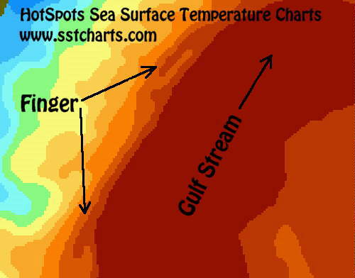
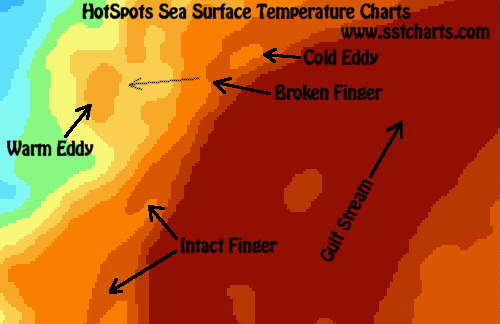
- Fingers are pockets of warm water that move west from the edge of the Gulf Stream.
- Fingers are connected to the Gulf Stream at their northern end. This connection continuously feeds warm water into fingers.
- Fingers move north with the Gulf Stream. The rate at which a finger moves depends on the size of the finger and how far it is from the edge of the Stream, but is roughly ˝ degree latitude in 24 hours.
- The currents in fingers move counterclockwise around the edge of the finger, which means the current at the western edge of a finger is moving south.
What is a backflow?
- Backflows are fingers that have gotten “stuck” and have stopped moving north. This happens at points where they Stream is diverted to the east, like at the Charleston Bump.
- Backflows can stay in place for several days, and sometimes grow, stretching farther to the south.
- The currents in backflows move counterclockwise around the edge of the backflow, which means the current at the western edge of a backflow is moving south.
What is an Eddy?
Warm Eddies:- Warm eddies are pockets of warm water surrounded by colder water.
- Warm eddies form when a portion of a finger becomes separated from the Gulf Stream.
- Warm eddies tend to be rounded, and the warm water in them circulates counterclockwise at 1 to 2 knots.
- Warm eddies are deepest and warmest at their edges.
- Cold eddies are pockets of cold water surrounded by warmer water.
- Cold eddies are deepest and coldest at their centers.
How Can Finding Fingers and Eddies Help Your Fishing?
- Fingers, backflows and warm eddies bring warm water west of the Gulf Stream, sometimes west of the 30 fathom contour. This is especially significant in the spring and fall, when water temperatures west of the Gulf Stream are relatively low.
- Game fish and bait that have been following the western edge of the Gulf Stream can often be found in fingers, backflows and warm eddies, having moved west with the warm water, avoiding the colder water that gets pulled up between fingers and the Gulf Stream.
- Rips usually form along the edges of fingers, backflows and eddies.
- Areas with good bottom structure will tend to be most productive when warmer water is moving through them.
- Areas covered by cold eddies should be avoided.
How Should Fingers and Eddies Be Fished?
- The western edge of fingers, backflows and warm eddies tend to hold productive rips. Start near the northwestern edge of a finger, backflow or warm eddy and search for these rips by moving toward the center of the feature. When a promising rip is found, mark its location and continue toward the feature’s center. Once you have identified the best rip, return to its location and begin fishing.
- Troll along the rip toward the south, following the counterclockwise current inside the feature. This is a more natural presentation, since baitfish tend to move with currents. It will also move your toward the tip of a finger or backflow, which may prove to be a productive area.
- If the rips along the edge do not prove productive, try moving into the center of the feature. As mentioned above, troll with the internal currents, moving south when west of the center,north when east of the center.
How To Use Sea Surface Temperature Information for
Green Water Fishing
The location of game fish is affected by two things: Comfort, and the availability of food. Water temperature can be the determining factor for both.
Comfort: Finding Areas With The "Right" Temperatures
Each species of offshore game fish has a water temperature range they prefer, and a wider range outside of which they will seldom be found. The following is a list of these temperatures for species in the Georgia coastal area.
| SPECIES | LOW | HIGH | OPTIMAL |
| King Mackerel | 70 | 88 | 75-78 |
| Spanish Mackerel | 68 | 88 | 72-82 |
| Cobia | 68 | 80 | 70-78 |
Bottom Structure
Green water fishing off the Georgia coast means fishing in significantly shallower water than blue water fishing. Bottom structure like live bottom, ledges, rock piles or other man-made "reefs" tend to hold bait schools in this shallower water, when water temperatures over these areas are right.
The "right" water temperature for these areas is relative and varies throughout the season. In general, a good temperature for bait and gamefish over near shore bottom structure is a degree or two cooler than the immediate coastal water (which can be a warm as the gulf stream's core from May through September), but is a degree or two warmer than the coldest water that usually sits between the coast and the edge of the gulf stream. Watch out for pockets of colder water that move across bottom structure. These can push bait and gamefish off of the structure.
In hotter months, sound entrances also tend to hold Spanish and cobia, and in some cases kings. Spanish and cobia can often be found around the buoys marking these entrances. Kings can be found around the offshore ends of deeper entrances, such as the Savannah River and Charleston Harbor entrances, which have been dredged to accommodate large ships. These gamefish will only be present in these sound entrances when schools of bait are present, so watch for diving birds and check your depth finder for these schools. Troll around these schools of bait, wherever they happen to be in the entrances.


 E-Mail HotSpots Charts, LLC